Hiking Mount Muhabura in Uganda: 7 Amazing Tips

Hiking Mount Muhabura in Uganda: A Complete Volcano Trekking Guide
Hiking Mount Muhabura in Uganda is a challenging, rewarding ascent through the volcanic highlands of Mgahinga Gorilla National Park. This detailed guide helps you understand the 4,127-metre mountain, plan the guided trail from Ntebeko, budget realistically, prepare for the weather and combine the climb with Kisoro’s wildlife and lakes.
Location: Mgahinga Gorilla National Park, near Kisoro • Summit: 4,127 m • Duration: allow a full day • Starting point: Ntebeko • Challenge: strenuous, steep mountain hiking • Access: guided park activity • Best approach: arrive the previous day and confirm current fees directly.

Why hike Mount Muhabura?
At 4,127 metres above sea level, Muhabura is the tallest of the three volcanoes protected by Mgahinga Gorilla National Park. Its almost symmetrical cone dominates the borderlands of southwestern Uganda and northern Rwanda. The mountain is not an easy lookout reached by vehicle; it is a long, sustained climb that rewards preparation and determination. On a clear day, the summit reveals a chain of volcanic peaks and valleys that make the Virunga landscape unforgettable. Visitors who enjoy demanding walks often find the mountain a memorable counterpoint to the region’s more famous primate encounters.
The mountain’s name is commonly translated as “the guide,” reflecting how its prominent shape served as a landmark. Hiking Mount Muhabura in Uganda is therefore both a physical adventure and a way to understand the geography surrounding Kisoro. It is particularly appealing to active travelers who want one substantial summit challenge without committing to a multi-day camping expedition. The reward is not a guaranteed panoramic photograph: weather may close in quickly, and the crater can be foggy. The real achievement is moving steadily through changing vegetation and reaching an unusually high volcanic landscape.
Where is the volcano located?
Muhabura stands on the Uganda–Rwanda border within the Virunga mountain chain. The Ugandan approach is through Mgahinga Gorilla National Park, a compact protected area near Kisoro. The same mountain is associated with Volcanoes National Park on the Rwandan side, but access arrangements and park authorities differ between countries. Travelers planning a Uganda-side ascent should organize it through the Ugandan park rather than assuming a booking in Rwanda covers the same trail. This distinction matters for transport, guides, fees and the meeting point on the morning of the climb.
Kisoro is the most useful gateway town for an early departure. The park entrance at Ntebeko lies outside town along a hilly road whose condition can vary after rain. Some visitors spend a night closer to the gate to reduce morning travel, while others choose lakeside maccommodation near Lake Mutanda. Both options can work if the transfer is organized in advance. The broader landscape includes cultivated hillsides, volcanic ridges and small communities, so even the approach drive provides a sense of place rather than feeling like an ordinary transfer between hotels.
How high is Mount Muhabura?
The commonly cited summit elevation is 4,127 metres, roughly 13,540 feet. That height makes Muhabura substantially higher than most casual walking destinations in Uganda. The exact gain on the day depends on where the group begins walking and how the park arranges access to the trailhead. Elevation alone, however, does not fully describe the challenge: the combination of steep ascent, changing ground, low temperatures and a return descent makes the outing demanding even for people who hike regularly at lower altitudes. Treat the day as a serious mountain excursion.
The summit has a small crater lake rather than the broad water-filled basin some visitors imagine from photographs of other volcanoes. Cloud can cover the crater entirely, and wind near the top may make a long rest uncomfortable. There is no reason to enter the water, and hikers should follow their guide’s instructions around the crater edge. The distinctive experience is standing high above the forested foothills and understanding how this peak connects to the neighboring Virunga volcanoes. Bringing a warm layer for the summit is important even if Kisoro felt pleasantly mild at breakfast.

What does the Mount Muhabura hike involve?
A typical Mount Muhabura hike is a guided day activity, beginning with an early briefing at the park’s Ntebeko visitor area. Rangers explain the route, expected conditions, safety procedures and the importance of keeping the group together. The walk is generally an out-and-back journey: you climb toward the crater and retrace the same terrain on the descent. Several accounts describe intermediate resting points, but their exact use depends on park operations and the guide’s decisions. Leave the whole day uncommitted instead of trying to schedule another major activity immediately after the mountain.
For further background, see the Mgahinga visitor highlights. Some independent descriptions quote around eight hours for a round trip, while other accounts give shorter or longer durations. Those differences are understandable because fitness, trail conditions, weather and group pace vary. Rather than treating any duration as a promise, plan for a full mountain day and discuss a realistic turnaround time during the briefing. If your group moves too slowly to reach the top safely, stopping below the summit is a sensible decision. Reaching your accommodation safely, with enough daylight for the descent, matters more than checking a summit box on a travel itinerary.
Plan a guided Muhabura summit hike
Hiking Mount Muhabura in Uganda: how difficult is it?
Mount Muhabura difficulty comes primarily from its sustained steepness, substantial altitude and the effort required for both the ascent and descent. This is not a gentle guided nature walk. You may encounter wet earth, uneven volcanic ground, roots, exposed sections and steps or trail improvements that are still tiring at altitude. A strong walker who comfortably completes long, hilly outings will have a better starting point than someone whose normal exercise involves short walks on level roads. Good balance matters because the downhill portion can strain knees after the legs are already fatigued.
Fitness should be viewed honestly and without unnecessary anxiety. You do not have to be a professional mountaineer, but you should be able to sustain uphill walking for hours while carrying water and extra clothing. A person who has recently climbed steep hills or taken regular long hikes is generally better prepared than a traveler relying on enthusiasm alone. If you have a medical condition that might be affected by intense exertion or altitude, seek personalized medical guidance before booking. The park guide can help determine whether the day’s conditions are suitable, but cannot replace advice from your own clinician.
Fitness preparation before the trip
For several weeks before departure, build a routine that includes brisk walks on hills, stair climbing and longer weekend hikes. Progress gradually rather than suddenly doubling your workload. Aim to feel comfortable walking uphill for extended periods without frequent breathless stops. Strengthening the legs with controlled step-ups and squats can also help with the descent. If you usually live near sea level, remember that gym fitness does not automatically remove the effects of altitude. The best preparation combines cardiovascular endurance, practiced downhill movement and a sensible willingness to slow down when conditions require it.
Train in the footwear you intend to use on the mountain. Boots that feel comfortable in a shop may rub after several hours of climbing, particularly when socks are damp. Carry a small daypack during practice walks so its straps and balance are familiar. Include breaks for food and drinking rather than waiting until exhaustion sets in. If you are traveling with friends whose fitness levels differ, discuss the possibility of separate activity choices ahead of time. A hiking itinerary should make everyone feel supported, not pressured into pushing beyond a safe personal limit.
Hiking Mount Muhabura in Uganda: altitude and safety
At elevations above 4,000 metres, thin air can affect people differently. Common warning signs of altitude illness include headache, nausea, unusual fatigue and dizziness. Tell your guide promptly if symptoms develop, especially if they worsen while you continue ascending. Do not try to conceal problems to avoid disappointing companions. A controlled pace, regular hydration and appropriate rest are helpful habits, but they do not guarantee that altitude symptoms will not occur. Descending under the guide’s direction may be necessary. Severe symptoms require urgent attention rather than an attempt to finish the climb.
The upper mountain can be cold, windy and wet even when the morning starts under clear skies. Clouds frequently move over the Virunga peaks and may reduce visibility. Keep waterproof clothing accessible, not buried at the bottom of a packed bag. Avoid standing on unstable edges for photographs and follow ranger instructions concerning wildlife and trail access. Guided Mgahinga volcano hiking helps visitors manage the route and understand park protocols. Independent wandering is neither an appropriate substitute nor a practical shortcut to the crater.

Best time to hike Mount Muhabura: choosing a season
The drier periods often associated with June through September and December through February are usually attractive for trekking, although mountain rain is possible in every month. Dry weather can make steep footing more manageable, yet it should never be treated as a guarantee of sunshine on the summit. During wetter periods, tracks may be muddy and clouds may arrive sooner. The best time to hike Mount Muhabura depends on your tolerance for uncertain weather, your available travel dates and how you plan to combine the climb with other experiences around southwestern Uganda.
Many visitors schedule the hike during the same months they hope to see mountain gorillas, which creates convenient connections with the region’s parks. The park’s own Mgahinga seasonal guide is worth consulting while deciding between travel windows. If your dates are fixed, preparation matters more than chasing an imaginary perfect day: pack rain protection, arrange transport and leave flexibility in the itinerary. A spare morning or day can be useful if severe weather forces changes, but any rearrangement remains subject to guide availability and park operating decisions.
Ask about hiking dates and current park fees
What to pack for the summit day
Start with sturdy, broken-in hiking boots offering dependable traction and ankle support appropriate to your experience. Wear quick-drying layers rather than relying on one heavy garment. A waterproof shell, warm fleece or insulating layer, gloves and a warm hat are sensible for the upper slopes. Long trousers can protect against vegetation, while a sun hat and sunscreen help on exposed stretches below the clouds. Pack drinking water, energy-rich snacks and a substantial lunch. Ask the operator what is provided rather than assuming a meal, walking stick or equipment will be waiting at the gate.
A small but comfortable daypack should hold extra socks, basic personal medication, blister care, a charged phone, tissues and a waterproof cover for valuables. Trekking poles may help on steep descents where permitted; confirm with the guide whether you need one or two. Avoid bringing heavy cameras, unnecessary electronics and bulky spare clothes that will slow you down. If you want to document the journey, prepare a simple weatherproof camera arrangement. Keep your hands available for balancing over difficult ground, and remember that the safest photograph is not necessarily the one taken closest to a ridge.
Volcano climbing permits and park fees
The Uganda Wildlife Authority manages guided volcano climbing in Mgahinga. Fees can differ according to residency category and may be revised between booking and travel. For example, its published 2024–2026 conservation tariff listed Mgahinga volcano climbing at US$100 for foreign nonresidents, US$80 for foreign residents and UGX 50,000 for East African Community citizens, with the listed mountain-activity fee including entrance fees. However, that tariff period has ended and the authority has announced further changes, so these figures must not be treated as confirmed current prices for a new departure.
Before paying, request the applicable official tariff for your travel date and ask whether the quotation includes the guide, entry, transport to Ntebeko, meals, porter support and any operator service charge. For a wider perspective, review things to do near Kisoro. An article about the cost of volcano hiking can help frame the questions, but the final payable amount should be confirmed directly with the booking provider. Ask about cancellation terms and what happens if conditions make the mountain unsafe. A transparent breakdown is more useful than a low headline price that excludes practical expenses on the day of the walk.
How to book a guided ascent
Begin by choosing your intended date and deciding whether the climb will be a standalone Kisoro excursion or one activity in a longer Uganda safari. Contact the Uganda Wildlife Authority or a reliable tour organizer to confirm whether the guided climb is operating, how places are reserved, and where to report. Provide the number of hikers and any information necessary for activity planning. Keep a written record of the confirmed meeting time and transport arrangement. Even if you have climbed independently elsewhere, do not assume this protected-area activity can be entered without the park’s approved guiding procedures.
If you are also planning primate activities, arrange those permits separately because they are not automatically included with a mountain hike. A traveler pairing the climb with gorilla trekking in Mgahinga should check both dates before reserving accommodation. The same principle applies to golden monkey trekking or a cultural experience. When plans involve several distinct park activities, make sure the organizer has allowed adequate recovery time. Booking the right services is not only about securing entry; it is about making the entire trip workable from the first pickup to the last transfer.
Getting to Kisoro from Kampala or Entebbe
Kisoro lies in far southwestern Uganda, so reaching the area from Kampala or Entebbe normally involves a long overland journey via Mbarara and Kabale. Allow a substantial travel day, with breaks for meals, road conditions and mountain bends. Do not plan to complete this drive and begin the volcano ascent the same morning. A stop near Kabale may work for travelers dividing the journey, particularly if they also want time around Lake Bunyonyi. The western Uganda scenery is beautiful, but a tight timetable can turn the approach into a tiring race against the clock.
Domestic flight options to Kisoro airstrip may reduce long road travel, depending on schedules, seat availability and weather. Flights still require a transfer to your lodge or the park. Travelers comparing air and road approaches can consult broader advice about fly-in safaris, remembering that the exact destination and vehicle transfer need separate confirmation. Whichever option you choose, arrive early enough to sleep well before the climb. Keeping an overnight buffer also protects the hiking day from avoidable disruption caused by a late arrival or a missed connection.
Arrange the Kisoro transfer and trail briefing
Arriving from Kigali and crossing the border
For some international travelers, Kigali provides an alternative starting point to southwestern Uganda. Driving through Rwanda can reduce the number of hours spent traveling across Uganda, but it introduces an international border crossing. Confirm your visa eligibility, passport validity, entry rules and permitted crossing hours for the specific route before committing to flights or transfers. Requirements can change and should not be assumed from a traveler’s old itinerary. Choose an operator who understands both sides of the transfer and who can arrange a comfortable arrival at Kisoro before your hiking date.
If your holiday also includes Rwanda, compare whether it is better to hike Muhabura from the Uganda side or plan different activities in Rwanda’s Volcanoes National Park. A guide to Uganda and Rwanda gorilla travel can help with broader routing decisions, though volcano access is a separate service. Avoid booking cross-border transport that depends on an implausibly fast immigration process. Build in time for paperwork, rest stops and possible road delays. Clear logistics are especially important before an early morning mountain start, when even a short late arrival can undermine the day’s safety margin.
Where to stay before the hike
Accommodation options include Kisoro town, properties near the Mgahinga entrance and scenic stays around Lake Mutanda. The best base depends on your budget, travel style and how much morning driving you are willing to accept. Staying closer to the trailhead can simplify departure, while Kisoro may offer a wider choice of services. Lakeside lodges can provide a peaceful setting, but the transfer from the water to Ntebeko should be checked carefully. Review the location, access-road condition and actual driving arrangement rather than judging a property solely by attractive views in its photographs.
Useful starting points are guides to accommodation near Mgahinga and places to stay in Mgahinga. Some visitors consider Mount Gahinga Lodge for a park-focused stay, whereas those seeking town convenience may explore Mucha Hotel in Kisoro. Availability, rates and amenities must be checked directly because property offerings change. Whatever category you choose, ask about an early breakfast, packed lunch, safe luggage storage and the pickup time for the hike. Rest and reliable transport will matter more on summit morning than elaborate extras at the hotel.
What you see along the trail
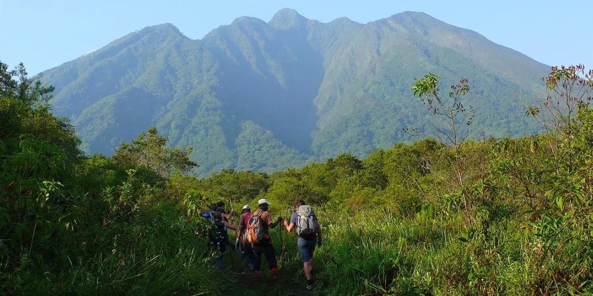
Part of the pleasure of hiking Mount Muhabura in Uganda is the gradual transition between habitats. Lower slopes may feel green and sheltered, giving way to bamboo and then more open heather and alpine-style vegetation as elevation increases. Giant lobelias and groundsels create an unusual mountain atmosphere, particularly when mist moves through the plants. The trail is not a zoo, so animal encounters are unpredictable, but birds, insects and signs of wildlife add interest at slower points. Your guide can explain how altitude, rainfall and volcanic soils influence the changing landscape.
Photographers should plan for quick stops rather than long staged sessions. Clear views can disappear in minutes, and morning light may be the most forgiving. Ask your guide before leaving the walking line to reach a viewpoint. Travelers interested in the wider ecosystem can read about Mgahinga flora and fauna before arriving. The park’s botanical variety is one reason the hike feels distinctly different from walking across a plain. Even if the summit remains hidden, the journey between vegetation zones provides rewarding scenery and a more intimate understanding of the Virunga mountain environment.
The summit crater and mountain views
The crater lake is small and exposed, so reaching it feels very different from arriving at a large lake reachable by road. In clear conditions, the high point can offer views across neighboring peaks, Rwanda and Uganda’s southwestern highlands. However, the summit may be fogbound. Keep your expectations flexible: visibility changes quickly, and the highest point is often the coldest part of the day. A successful climb can still be meaningful without a perfect skyline photograph. Listen to the guide about how much time is available at the top before the descent must begin.
Do not step away from the approved path to photograph the crater from a risky angle. Wet rock, loose soil, sudden gusts and tired legs can combine dangerously. A few carefully chosen pictures are better than a rushed attempt to explore the rim. If clouds lift briefly, appreciate the moment rather than spending all your time adjusting camera settings. Many visitors say the strongest memory is looking back down the steep cone and recognizing the distance climbed. The landscape feels especially dramatic because the volcano stands above a region of lakes, farms and other volcanic peaks.
Build a volcano and gorilla safari
Muhabura versus Gahinga and Sabyinyo
Mgahinga offers three distinctive volcano climbs. Muhabura is the highest, making altitude and sustained ascent the defining challenges. Mount Gahinga hiking is often considered a somewhat gentler mountain option, although it still requires proper fitness and a guided outing. Sabyinyo is famous for a jagged summit profile and steep, exposed sections that can involve ladders. The best choice depends on whether you prefer the highest viewpoint, a forested volcano or a more technically exposed trail experience. Ask about the current route condition instead of ranking difficulty solely by summit elevation.
Travelers comparing the peaks should avoid relying on photographs alone. The three mountains differ in terrain, weather exposure and the type of effort required. A fit hiker who dislikes ladders might prefer Muhabura, while someone particularly sensitive to altitude might choose a lower outing. Consider how much time you have for recovery, especially if a gorilla trek follows immediately afterward. The most satisfying itinerary often includes one well-chosen mountain rather than an exhausting sequence of activities. Mgahinga’s variety allows visitors to tailor the challenge to their abilities without losing the atmosphere of the Virungas.
Gorilla trekking after the climb
Mgahinga is also known for mountain gorilla tracking, a very different form of guided adventure. A gorilla trek involves following ranger instructions through forest terrain to observe a habituated family, whereas a Muhabura ascent focuses on reaching a high volcanic summit. The park’s Nyakagezi gorilla family is a central part of its tourism identity. If you want both experiences, schedule them on separate days and consider a recovery buffer. Sore legs from the descent can make a difficult forest trek much less enjoyable the next morning.
Permits for gorilla tracking are limited and subject to separate rules, booking procedures and age restrictions. Check the current arrangements through Mgahinga gorilla permits and do not treat a volcano-climbing receipt as a substitute. If your trip includes neighboring Bwindi Impenetrable Forest, discuss which park fits your travel dates and route best. The combination can be excellent for active travelers, but it rewards realistic scheduling. A little extra time for forest exploration and rest often improves the trip more than squeezing several expensive activities into consecutive rushed mornings.

Golden monkeys and other park experiences
The bamboo habitats around Mgahinga support golden monkeys, among the region’s most engaging primates to observe. Guided tracking normally emphasizes watching their movement and feeding behavior rather than reaching a mountain summit. This offers a useful contrast for visitors whose companions do not want a long, steep ascent. Learn how the golden monkey experience differs from the golden monkey habituation activity before deciding what to book. Each has its own timing and fees, and neither should be assumed to be included with a volcano climb.
The park also offers cultural interpretation associated with the Batwa people, whose historical relationship with the forest is important to the area. A thoughtfully arranged Batwa cultural experience can add human context to the volcanic landscape. Choose experiences that are community-led and respect participants, rather than treating cultural encounters as performances for photographs. For birdwatchers, guided walks may reveal Albertine Rift species and other forest birds, although sightings depend on conditions and luck. These options help mixed-interest groups enjoy Mgahinga without expecting every traveler to attempt the mountain summit.
Lake Mutanda and nearby places to unwind
After a tough climb, a quieter day around Lake Mutanda can be particularly appealing. The lake sits amid the southwestern highlands and provides opportunities for scenic views, boat outings or a simple afternoon enjoying the landscape. Activity availability depends on the local provider and conditions. A planning guide to things to see around Lake Mutanda can help you decide how much time to allow. Avoid scheduling an energetic transfer or another strenuous trek immediately after Muhabura if your legs normally need recovery after steep descents.
Lake Bunyonyi, further east near Kabale, is another attractive stop for a broader circuit. Depending on the route, visitors can enjoy views of islands, birdlife and village landscapes while breaking up a long road journey. Consider Lake Bunyonyi boat safaris if a calm water-based activity suits your plans. Neither lake should be treated as an automatic inclusion in a one-day mountain package; transport and overnight stays require separate arrangements. These slower experiences balance the intensity of volcano climbing and provide more time to appreciate southwestern Uganda beyond its headline wildlife attractions.
Explore Mgahinga with a tailor-made itinerary
A practical three-day hiking itinerary
Day one: travel to Kisoro or the Mgahinga area and arrive before dark where possible. Check into your accommodation, confirm the following morning’s pickup and prepare your pack. Have an early dinner and ask about breakfast or a packed meal. If road travel has taken longer than expected, prioritize rest over adding an unplanned sightseeing stop. A comfortable first evening helps you begin the hike alert, hydrated and properly equipped. Visitors who have just arrived from a long international flight may prefer another quiet day before attempting a steep climb at significant altitude.
Day two: report for the park briefing, complete the guided ascent and descend according to ranger advice. Do not assume a fixed summit arrival time; the group’s fitness and weather will shape the schedule. Return to your lodge for food, dry clothes and rest. Day three: choose a relaxed lake visit, a community activity or a previously booked primate experience if you feel recovered. If you prefer an established route, look at a four-day Uganda gorillas and golden monkeys itinerary as inspiration for nearby wildlife components, then ask the operator to adapt the plan around your summit date.

Budgeting for the entire hike
A realistic Mount Muhabura budget includes more than the published park activity fee. Add transport from the airport or border, nights near Kisoro, meals, drinking water, suitable clothing, porter arrangements if needed and an appropriate allowance for operator logistics. A private vehicle may cost more per person for a solo traveler than for a small group sharing the same route. Accommodation also varies widely by location and comfort level. Ask for a written quote showing what is included and excluded, preferably in the same currency used for payment, before comparing offers from different companies.
Avoid choosing the cheapest quote without understanding the schedule. A late pickup, inadequate vehicle or unrealistic driving plan can make a mountain outing uncomfortable or unsafe. It may be worth paying for an extra night near the park rather than rushing from a distant hotel. If combining experiences, compare the full itinerary cost rather than single activity prices. You may also find useful planning context in a guide to Uganda safari itineraries and broader travel planning around Kisoro. A good-value itinerary gives the mountain adequate time and respects the energy required.
Responsible hiking in a protected landscape
Stay with the ranger, keep to marked trails, carry out rubbish and give wildlife space. Respect the people who guide and support your journey. The Virungas are a protected ecosystem, not merely a summit challenge.
For more on conservation and community value, see why Mgahinga is worth visiting. Choose operators who respect park rules and treat local porters and guides fairly.
Common planning mistakes to avoid
Do not underestimate the full-day altitude challenge, arrive without waterproof layers, or schedule a lengthy transfer immediately after descending. Allow time for changing weather, confirm fees and transport in writing, and choose a summit attempt that matches your fitness.
Cloud and strong wind can hide the summit or force a turnaround. Respect the ranger’s decision and focus on the mountain experience rather than a guaranteed photograph.
Request a personalized Muhabura hiking plan
Frequently asked questions about Muhabura
Is Muhabura a one-day climb? Yes, the Uganda-side guided ascent is normally organized as a full-day activity. Exact walking time changes with weather, pace and the route conditions. Is a guide required? Park-managed volcano climbing is guided, so coordinate with the relevant authority or operator. Can beginners climb it? A newcomer with strong hill fitness may cope better than an experienced walker who has not trained recently, but the steepness and altitude mean this is not the ideal first demanding hike. Speak openly with the guide and choose a realistic objective instead of relying on a broad beginner label.
Is it possible to see the crater lake? The small lake is at the summit, but weather and safety conditions determine whether the group reaches it and how clearly it can be seen. What is the right season? Relatively drier months may improve footing, yet rain can fall year-round. Can it be paired with gorillas? Yes, provided the relevant activities are booked separately and enough rest is allowed. Where should you sleep? Kisoro, the park vicinity and Lake Mutanda are practical bases. The decisive factor is arranging a reliable early transfer to Ntebeko and arriving properly rested for the ascent.
Final advice for a rewarding Uganda volcano adventure
Hiking Mount Muhabura in Uganda deserves a place on the itinerary of travelers who love a genuine physical challenge and want to explore a less hurried side of the Virunga Mountains. Its appeal comes from the combination of altitude, volcanic scenery and the satisfaction of completing a serious day outdoors. Prepare carefully, choose appropriate equipment and listen to your ranger. Build the route around safe walking rather than an inflexible timetable. Whether the summit opens onto sweeping views or disappears into cloud, the mountain offers a distinctive encounter with southwestern Uganda’s highland environment.
Confirm current UWA arrangements before paying and stay near enough to Ntebeko for an early start. A recovery day with lakes, wildlife or forest activities makes the climb easier to enjoy. Request a tailored plan that states exactly what is included.
Planning note: park fees and operating arrangements may change. Confirm current conditions with Uganda Wildlife Authority before booking. Image source URLs are taken from the supplied WordPress media export; live availability could not be independently established.